
Sacramento District USACE California USA
From 2010 – To 2012
Final Model Submitted to the prime consultant

President and Senior Consultant
pmcraig@dsi.llc
Chief Engineer
ntlam@dsi.llc
The Sacramento San Joaquin River Delta (Delta) is the largest estuary on the west coast and covers more than 738,000 acres. The study area for this project is the San Joaquin River Delta from Vernalis to Suisun Bay, and the Sacramento River from Freeport to its confluence with the San Joaquin River, and from Suisun Bay and west to Carquinez Strait.
There are up to 68 independent flood risk reduction, ecosystem restoration, and/or water supply (conveyance) projects throughout the Delta that require a comprehen- sive watershed approach to meet the region’s water-related needs, improve public safety, sustain the economy, and rehabilitate the ecosystem. A necessary first step as part of the comprehensive watershed approach is the collection and evaluation of the existing data and development of a coarse hydrodynamic and sediment transport model of the Delta.
The goal of this study was to continue the development and refinement of the two- and three- dimensional model of the Sacramento- San Joaquin Delta. This included calibration and validation of the Delta Environmental Fluid Dynamics Code (EFDC) Hydrodynamic Model, as well as the Sediment Transport Model.
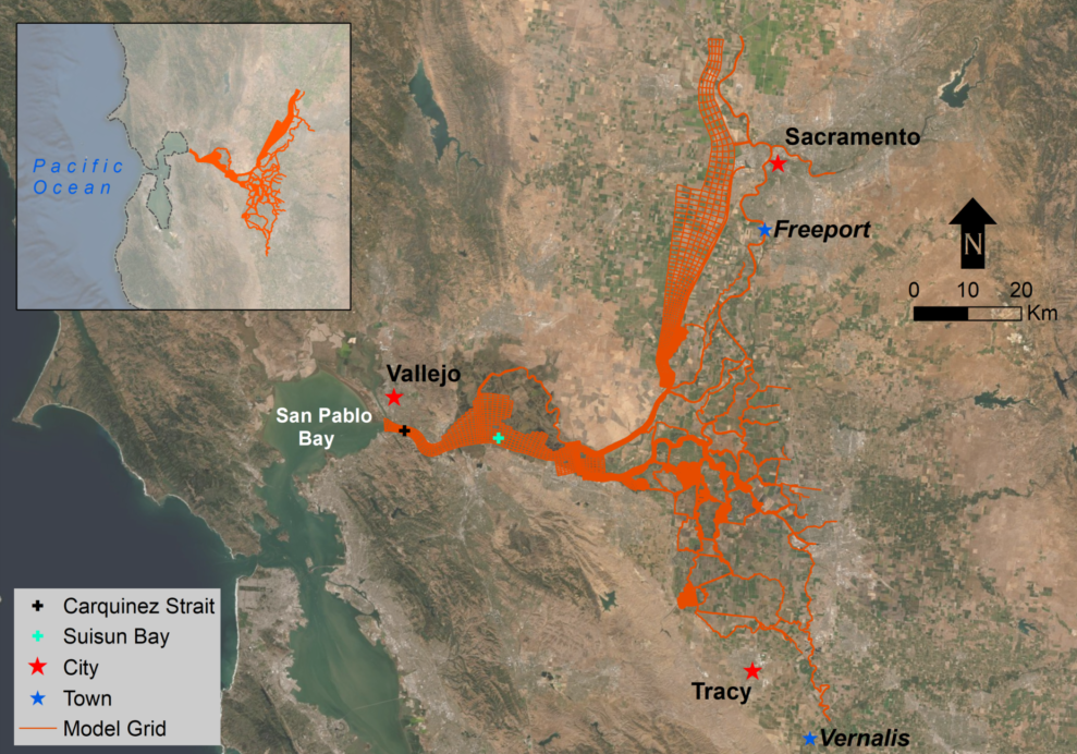
Sacramento-San Joaquin Delta Grid for Model Simulation.
DSI developed a 3-Dimensional hydrodynamic and sediment transport model for the Delta using EFDC and EFDC_Explorer. The model included 11,708 horizontal cells and four vertical layers to provide a sophisticated structured grid representation of this highly complex waterbody. We calibrated the model for observed flow, salinity, water temperature, and total suspended solids using the data from more than ten stations in the Delta. The model also included five river bed layers with morphology changes during model simulation. These results provided information and the location of sediment deposition or erosion in the system. The model development process also included sensitivity analysis using key parameters and uncertainty analysis.
We submitted the final model and accompanying report to the prime consultant and USACE. The model went through technical review and it was accepted to be used for advanced watershed management, ecosystem restoration, water storage and water quality planning and management.